I thought a fun follow-up to my post about running out of gas on a road trip would be documenting what I had to do to figure out what happened when.
Also: because of my digital archive and research, I updated some of the locations in the original post to reflect that. Thanks for your patience.
Swiss-cheese memories
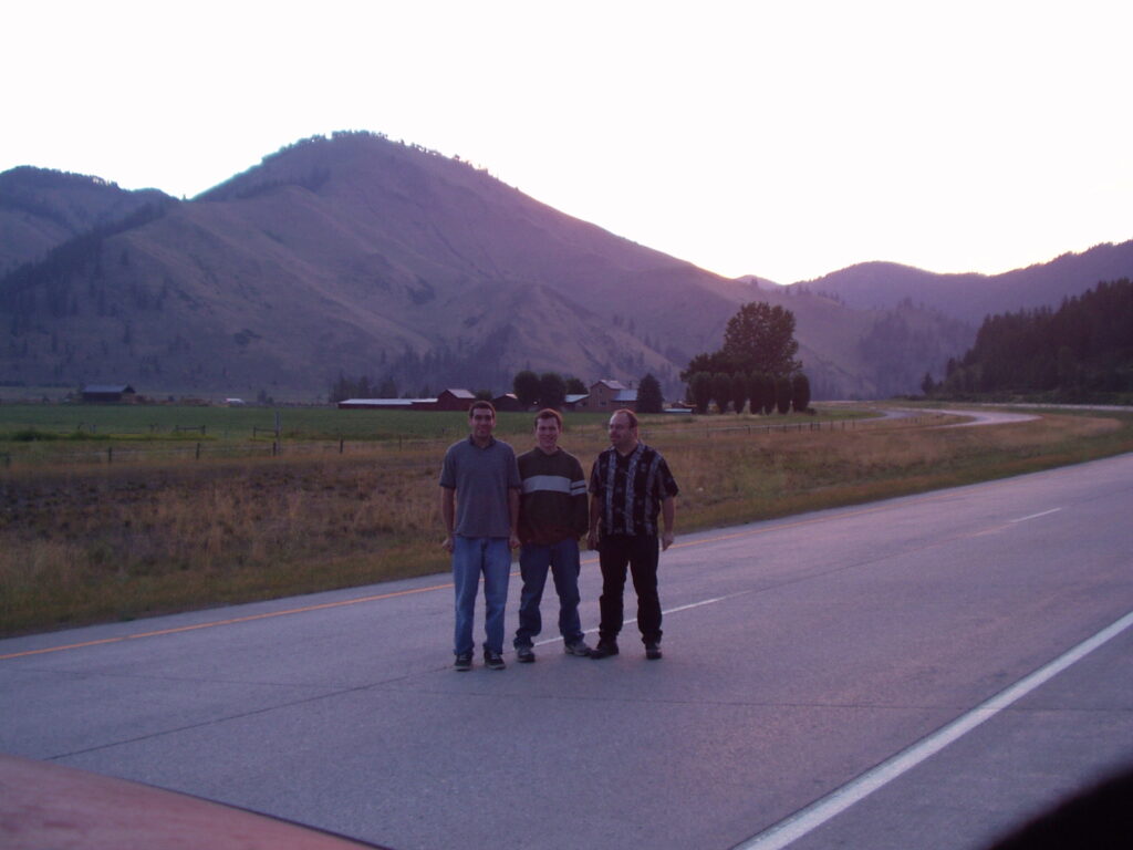
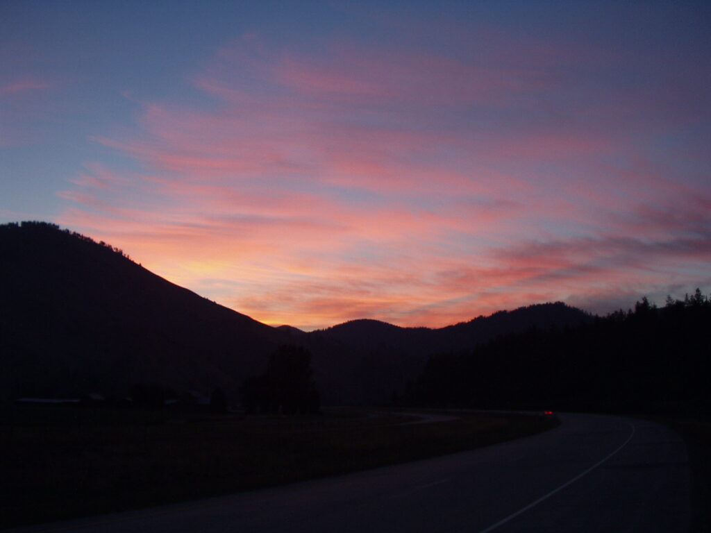
When I wrote the first draft I just guessed the details based on my memory of events. Since they were 22 years old, those memories were not accurate. What I remembered was: taking pictures of the sunrise, then giving up driving for a nap while Caleb drove, then some time later, in the daylight, waking up to the car running at maximum speed and getting a picture.
After wrapping that up, we pulled into the closest town. According to the map, the closest town to the Idaho-Montana border was Superior, and I vaguely remembered a diner there.
I do remember Jake saying we should fill up the tank as we drove into (a) town and assumed it was the same one we had breakfast in. According to my memory, the next major event was, of course, running out of gas, and Jake going off with the old couple in the RV. I had no idea where we were when that happened; we were just “somewhere in Montana”
Those were the events, in roughly the order they happened, but my first draft had them all happening before noon on 20 July 2002, in western Montana. That’s not right!
Start with what I know to be true
For a starting point, I knew that we pulled over to take pictures of the pre-dawn mountains, and a simple Google search showed that sunrise in Montana on 20 July was at 5:46 AM. Roughly that placed us on the map, give or take.
I had pictures from that trip. Digital pictures that were saved in my Photos library and therefore available right on my iPhone. Those photos followed me, from my old iBook back in 2002 down through the years and many laptops and phones, to my current iPhone 13 Mini. Gotta admit that’s kind of cool!
The camera was an Olympus Camedia C-220, Zoom (yes that was its name). It did not have location or time data capability; consumer electronics did not have that feature back then. I added location data later, in iPhoto on my Mac when Apple added that feature, and I tagged them by date taken, but beyond that the only information was in the pictures themselves.
Searching old albums (digitally)
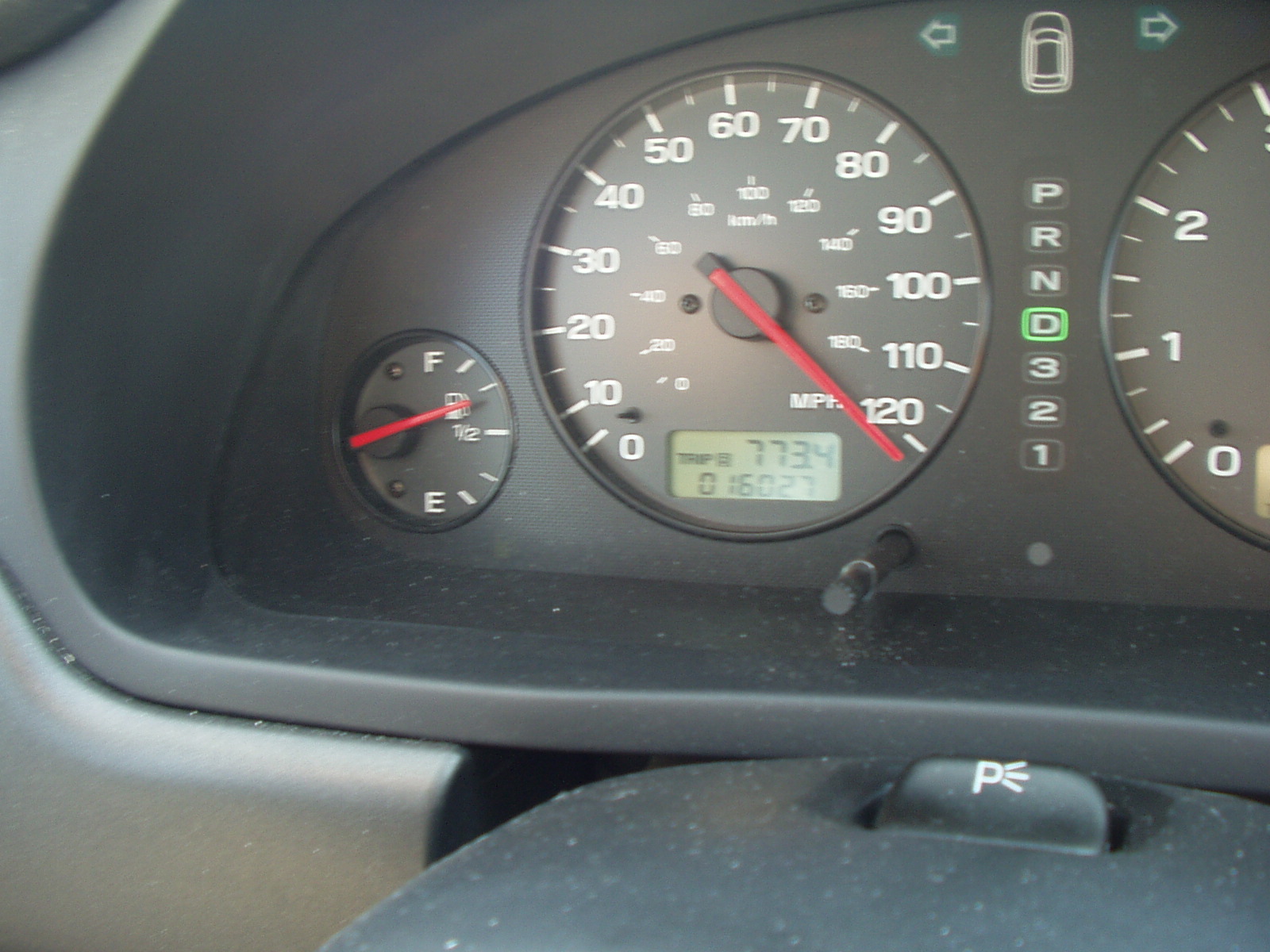
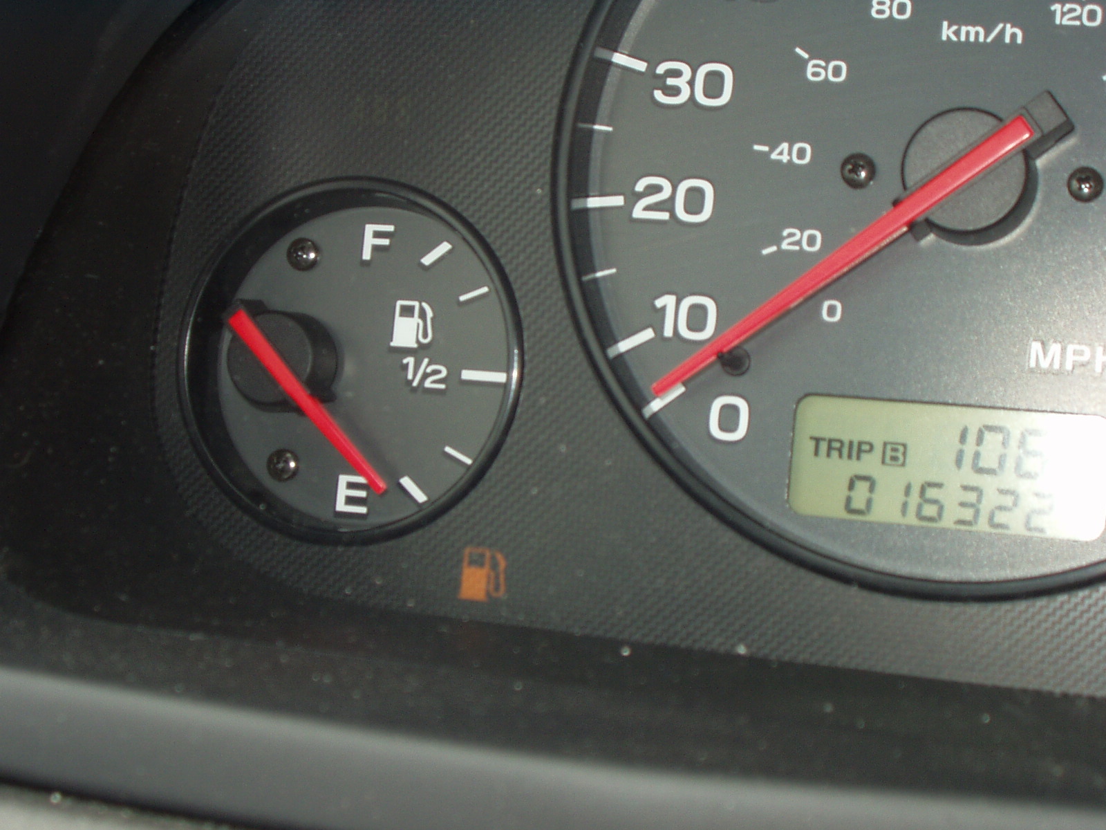
I quickly found the speedometer picture we took while speeding, and the gas gauge picture showing the empty tank. I had to include those in the post. But comparing the pictures to my memory showed a contradiction: did we really burn through 3/4 of a tank in just a couple of hours? Seems unlikely.
Back to my photo library, where a search for “Montana” revealed a picture of the speeding ticket! OCR on my phone is a miracle when it works. This was a huge score. So much good info preserved there, including the time the ticket was written: 10:25 AM. This told me that we had continued for at least five hours after sunrise. That means we were a minimum of 400 miles east (assuming 90-100 MPH sustained) of the Idaho-Montana border on I-90, which puts that speeding stop about 50 miles west of Billings.
Triangulating from there
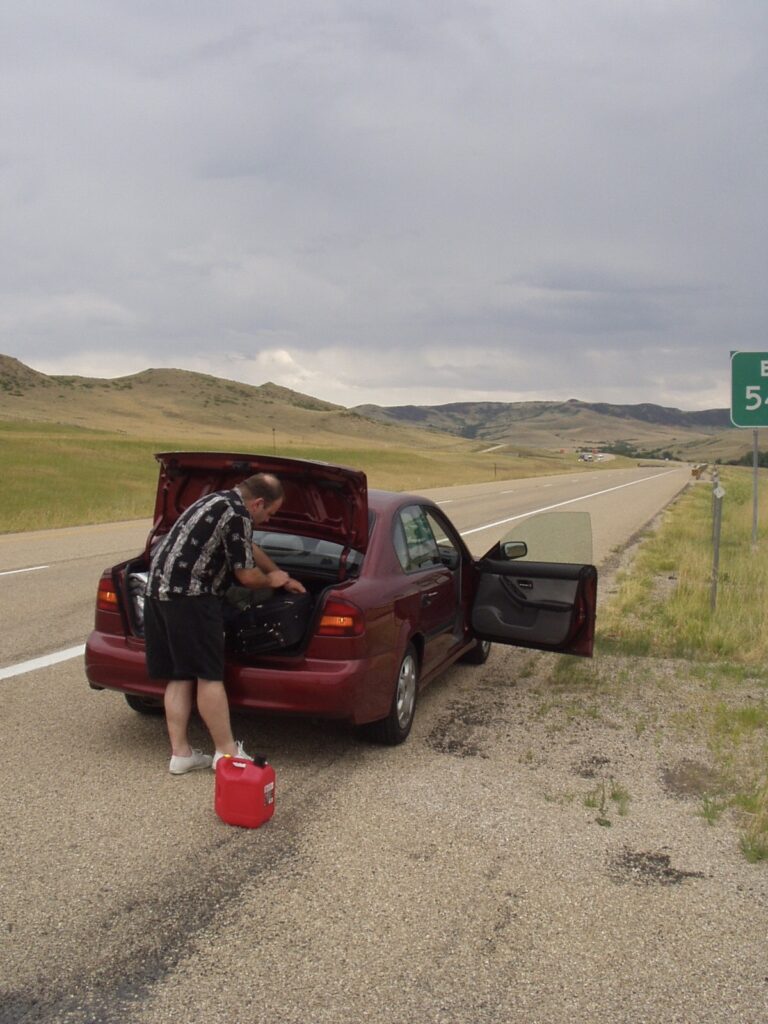
Next, comparing the odometer in both of the pictures referenced above, we put 295 miles on the rental between the two pictures. So, where did we run out of gas? I found another image from that day in 2002 of me, standing next to the trunk, with a gas can on the ground (Caleb or Jake had taken the picture; probably Caleb). On the right edge of the frame is an exit sign: Exit 5something.
The exits on I-90 in Montana are numbered low to high, west to east, and I knew our gas stop was closer to the eastern border than the western. Looking at a list of exits for that highway, I found only one viable candidate: Exit 544, for Wyola, MT. I looked it up in Google and used Street View and confirmed: that was absolutely the same place. I even clicked down to the bottom of the off-ramp and saw the sign I clearly remembered: No services.
No Services
Wyola is less than 100 miles by car from Billings, and the maximum range on that Subaru Legacy was more than 300. Where did we last fill up the tank? It couldn’t have been Billings. We must have stopped somewhere else west of Billings for lunch or something else. Where were we when Jake reminded us to fill up while driving in? 320 miles west of Wyola is Butte, and it’s hard to imagine three guys on a road trip not stopping in a city called Butte. Right? That’s where we had our lunch.
Finally, to satisfy my curiosity, I looked at restaurants in Butte to see if I recognized one. I found an Annie’s Cafe, which very much feels like the kind of place we would choose, but the user-submitted pictures do not ring a bell for me. Change is inevitable in two decades, yeah?
PostScript: Full Chronological Order
All events listed occurred on 20 July 2002
- 5:30 AM – We pull over just past the Idaho-Montana border, near Sohon, MT, and take pictures of ourselves and the sky before sunrise.
- 9:00 AM – We stop in Butte, MT (hehe, butt) for breakfast and gas.
- 10:00 AM – Approximate time we pegged the speedometer at over 120 MPH indicated, west of Billings, MT.
- 10:25 AM – Montana State Trooper pulls us over and cites us for “Exceed(ing) the posted speed limit by (more than) 25 MPH” @ 92.5 MPH. Fine paid: US$40.00, cash
- 11:30 AM – Approximate time we arrived in Billings. Jake reminded us to fill up the tank. We did not.
- 11:30 AM – 12:30 PM – lunch break in Billings. Establishment unknown.
- 1:30 PM – Approximate time we ran out of gas, at Exit 544, near “No Services” Wyola, MT.